
Ho Chi Minh City, often known as Saigon, is a vibrant metropolis at the heart of Vietnam’s southern region. This bustling city intertwines history, culture, and modernity, offering visitors a unique glimpse into its geographical richness. The city’s landscape is an intricate tapestry of rivers, canals, and districts, shaped by various historical influences and natural features. With a tropical climate, Ho Chi Minh is not only a hub of urban vibrancy but also a place teeming with natural beauty and complex terrain. As we delve into the geographical intricacies of Ho Chi Minh City, the richness of its topography and the significant role it plays in Vietnam’s socio-economic landscape will unfold.
Saigon River and Canal Systems: Lifeblood of the City
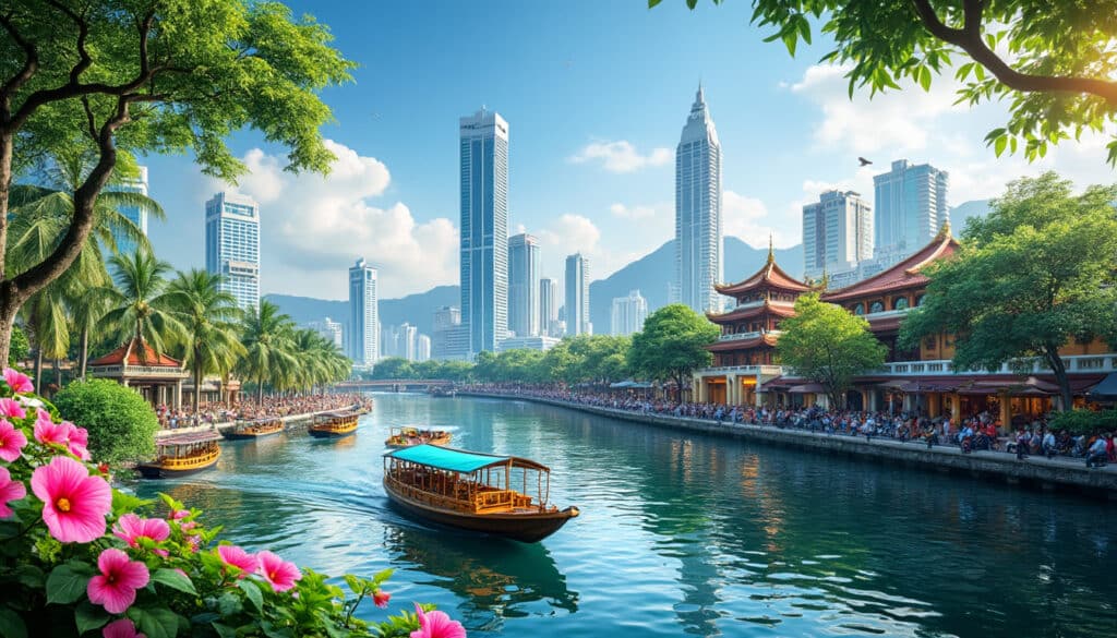
The Saigon River is not just a body of water but the lifeline that has historically sustained Ho Chi Minh’s growth and development. Originating from the southeastern part of Vietnam, the Saigon River flows majestically through the city, providing not only an essential waterway for trade but also contributing to the lush greenery and fertile lands surrounding the region. This river is pivotal in shaping the city’s geography, flowing over 80 kilometers and eventually merging with the Dong Nai River.
Accompanying the Saigon River is the complex network of canals and channels, with the Bến Nghé Channel being a notable one. This channel weaves through the city, indicative of the city’s adaptation to its deltaic environment. Historically, these waterways have fostered trade routes that brought economic prosperity and cultural exchange, transforming Ho Chi Minh into the commercial hub it is today.
Navigating the Saigon River is a journey through the city’s colonial past, with the possibility of seeing historical landmarks such as the Independence Palace. River cruises offer a fascinating view of the cityscape, demonstrating the blend of natural beauty with urban dynamism. The riverbanks are lined with modern skyscrapers and traditional dwellings, portraying a microcosm of Vietnam’s illustrious history intertwined with modernity.
One cannot discuss the Saigon River without mentioning the environmental challenges it faces. The rapid population growth and industrial activities have led to pollution, which poses a threat to the river’s ecosystem. Efforts are underway to mitigate this impact through sustainable development and stringent regulations.

Thus, the Saigon River and its tributaries are not only geographic features but are also deeply embedded in the cultural and economic fabric of Ho Chi Minh City, shaping its identity and future.
Mekong Delta Influence: From the Fertile Lands to Urban Legend
Ho Chi Minh City’s geographical relationship with the Mekong Delta is one of harmony and dependence. The city sits just north of the delta, benefiting enormously from its fertile lands and abundant resources. This connection has long been a cradle of rice production and agriculture, feeding the city and supporting its population.
The Mekong Delta is known for its vast network of rivers and canals that stretch like veins across southern Vietnam. These waterways contribute to the region’s rich biodiversity and are home to a variety of marine and bird life. Agriculture thrives here due to the nutrient-rich sediment deposited by the delta, making it one of the most productive agricultural regions in the country.
The influence of the Mekong Delta extends beyond agriculture. It has shaped the socio-economic fabric of Ho Chi Minh City, with much of the city’s population reliant on the trade and transport routes facilitated by the delta’s waterways. This interdependence is evident in the city’s bustling markets, such as the famous Ben Thanh Market, where goods from the delta are sold alongside local and international products.
Furthermore, the deltaic environment presents unique climatic conditions, notably the high humidity and monsoon rains that characterize the region’s tropical climate. This environment has necessitated adaptability in the city’s infrastructure and lifestyle, as urban development must consider the risks of flooding and the benefits of water-based transportation.
Ho Chi Minh City’s urbanization has also encroached upon parts of the delta, leading to significant environmental changes. Urban sprawl and industrialization have placed pressure on the natural resources, prompting initiatives to balance growth with conservation efforts.
In essence, the Mekong Delta’s impact on Ho Chi Minh is profound, affecting everything from food security to economic activities, and shaping the city’s cultural and environmental landscape.
The Topography and Terrain of Ho Chi Minh City
At a glance, Ho Chi Minh City covers an extensive area characterized by low-lying terrain with slight elevation variations. The city spans across 2,095 square kilometers, with the city center averaging an elevation of 5 meters above sea level. This modest elevation defines the city’s vulnerability to flooding, particularly in areas near the Saigon River and its canals.
The city’s layout is a blend of natural and human-made geographical features. The historic districts boast colonial architecture, offering a contrast to the modern high-rises that have sprung up over the past few decades. Areas such as Thao Dien Ward highlight the city’s diverse topography—a fusion of urban living with scenic riverside views and lush green spaces.
Ho Chi Minh City is divided into various districts, with Cholon District being one of the most notable. It is home to a large Chinese-Vietnamese community and serves as a testament to the city’s multicultural tapestry. This district exemplifies the mild undulating terrain which gradually ascends towards the north, offering a unique perspective on the city’s geographical diversity.
Despite its generally flat landscape, the city is surrounded by areas of significant geographical interest, such as the Cu Chi Tunnels. These tunnels were part of a complex underground network used during the Vietnam War, which now serve as a historical monument and a reminder of the landscape’s role in the city’s storied past.
Given the city’s rapid growth and urbanization, there’s an ongoing challenge to maintain a balance between development and environmental preservation. Initiatives to develop green urban spaces and improve flood management systems are integral to the city’s plans to mitigate the effects of climate change on its geography.
This geographical blend of low elevation, historical landmarks, and modern districts defines Ho Chi Minh City, painting a picture of a city where history and progress coalesce harmoniously.
Climate and Weather Patterns in Ho Chi Minh City
Ho Chi Minh City’s tropical climate is a defining feature of its geography, influencing both daily life and long-term urban planning. The city experiences two main seasons: the wet season, from May to November, and the dry season, which spans December to April. This duality in climate is marked by significant rainfall during the wet season, which can lead to flooding in low-lying areas. The city’s leadership is actively working on flood management infrastructure to combat these seasonal challenges.
Average temperatures in Ho Chi Minh are warm and consistent throughout the year, with an average of 28 degrees Celsius. The warmth is accompanied by high humidity, ranging from 78% to 82%, making it essential for buildings and public places to embrace designs that promote ventilation and air circulation.
Extreme weather events, although not frequent, are impactful when they occur. The city has initiated plans to improve its resilience against such events by bolstering its infrastructure and implementing sustainable urban designs that include ample green spaces to absorb excess rainfall.
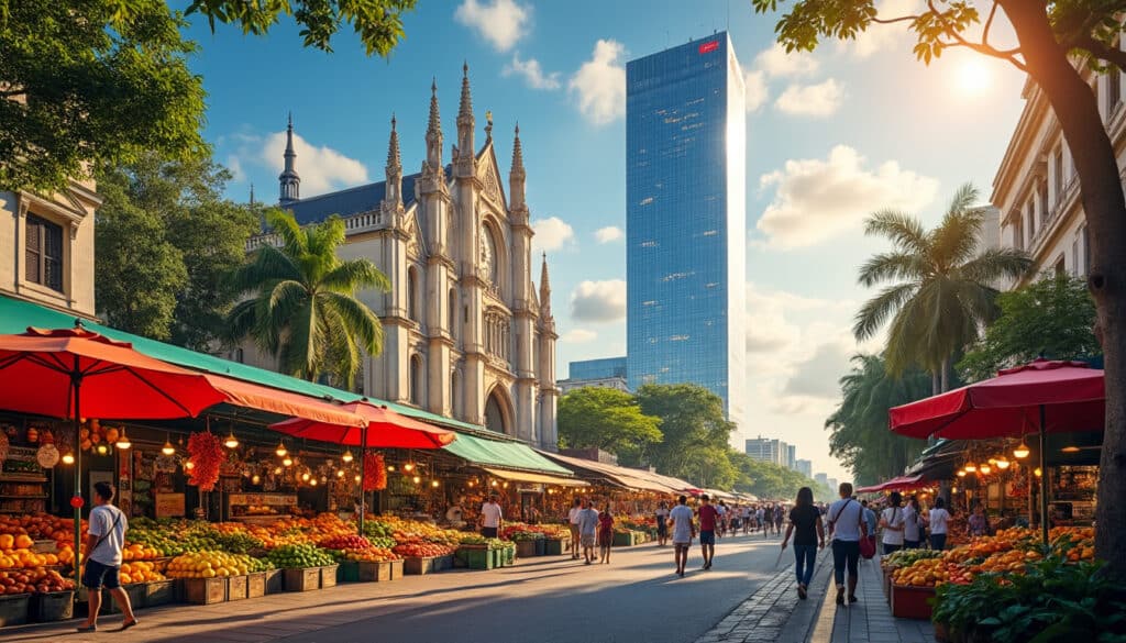
One of the distinct weather patterns of Ho Chi Minh is the bright sunlit days, contributing to a flourishing street food culture and vibrant outdoor markets. The pleasant evenings, especially during the dry season, are perfect for exploring cultural landmarks such as the Saigon Notre-Dame Basilica and Saigon Skydeck.
Adapting to these weather patterns involves strategic urban planning and public awareness campaigns designed to safeguard the city’s infrastructure and heritage while adapting to ongoing climatic changes. Learning about the city’s climate adds another layer to understanding its rich geographic and cultural landscape.
Districts and Subdivisions: Mapping the Urban Landscape
Ho Chi Minh City’s geographical features are not just natural but are also defined by its distinctive districts and subdivisions. The city’s expansive area is divided into 24 districts, which include 19 urban and 5 rural districts. Each district offers a unique insight into the city’s diverse landscape and cultural fabric.
District 1 is the city’s financial heart, characterized by modern skyscrapers, gleaming offices, and busy streets. It is here one finds some of the city’s most renowned attractions, such as the Saigon River’s scenic views and the bustling Ben Thanh Market. A stroll through District 1 is incomplete without experiencing its blend of commerce and culture.
District 3, known for its tree-lined boulevards and colonial architecture, offers a more relaxed atmosphere. It is home to historical sites and a thriving artistic community, making it a popular destination for those seeking a cultural perspective of the city.
The Cholon (Chinatown) District is vibrant and truly showcases the cultural diversity of Ho Chi Minh. It’s where rich heritage meets commerce in colorful streets filled with bustling markets, traditional Chinese architecture, and unique dining experiences.
Suburban districts like Cu Chi and Nha Be provide a contrast to the inner city’s hustle and bustle, featuring more expansive landscapes and a slower pace of life. Areas such as Cu Chi are famous for attractions like the Cu Chi Tunnels, offering historical insights into the guerrilla warfare tactics used in the Vietnam War.
Mapping Ho Chi Minh City’s urban landscape involves understanding the dynamic interplay between its historical legacy, cultural diversity, and geographical layout. Each district contributes to the city’s identity, adding to the unique tapestry that defines Vietnam’s largest metropolis.
Frequently Asked Questions
Q: What is the best time to visit Ho Chi Minh City?
A: The best time to visit is during the dry season from December to April, when the weather is more predictable and suitable for exploring outdoor attractions.
Q: How does the city manage its flooding issues?
A: The city is implementing a variety of flood mitigation strategies, including enhancing drainage systems and promoting green urban spaces to absorb rainwater.
Q: Why is Ho Chi Minh City’s geography significant?
A: Its strategic location at the heart of the Mekong Delta, rich natural resources, and historical waterways have contributed to its development as a vital economic and cultural hub in Vietnam.
Nature and Geography of Ho Chi Minh
The vibrant metropolis of Ho Chi Minh City, often known by its historic name Saigon, is much more than the bustling urban landscapes characterized by its skyscrapers and hectic streets. Nestled in the southeastern part of Vietnam, this city presents…
Location and coordinates of Ho Chi Minh
Ho Chi Minh City, known for its vibrant culture and bustling streets, stands out as a pivotal point on the map of Vietnam. As we navigate through the city’s geographic coordinates, one can’t help but be enchanted by its rich…

Nature and wildlife in Ho Chi Minh
When one thinks of Ho Chi Minh City, the images that often come to mind are bustling streets, scooters weaving through traffic, and skyscrapers stretching toward the sky. Yet, hidden within this urban jungle are pockets of serene natural beauty…

Rivers and water near Ho Chi Minh
As urban explorers traverse the sprawling, bustling streets of Ho Chi Minh City, they encounter a juxtaposition of modernity and history. Nestled within this urban jungle lies a network of rivers and waterways that not only define the city’s landscape…